
View from the Bernal Hill Loop Trail towards the Mounted Ranger
Unit at the Buck Norred Ranch Site
Note from Sam Drake on the fire:
As many of you already know, there was a grass fire at Santa Teresa Park today. CDF and San Jose Fire got it under control in under 90 minutes. It seems to have started at the Water District's Canal, just east of Santa Teresa Spring, near Manila Way. Once started it quickly headed uphill and was blown to the southeast, over towards the old Buck Norred Ranch...It was quite something to see the CDF teams go to work - they did multiple full air drops of bright orange fire retardant from tanker planes, as well as dozens of water drops from helicopters. After the fire was under control, one of the helicopters landed in the Bernal Intermediate baseball fields to stow the water bucket they had been using, then took off again.
Sam Drake's Pictures:


The pictures below were taken the day after
the fire on 10/9/05. The fire was completely out. There were no fire crews
around.
Click on the thumbnails below for a larger picture,
then hit the "back" button on your browser to return.
View from the Bernal Hill Loop Trail:
These were taken from the Bernal Hill Loop Trail, at the corner where it goes near the big towers above the Pyzak Ranch. This shows where the fire stopped, just about under the power lines, which
were too high to be affected by the fire, but must have posed a hazard
to aerial firefighting. The Pyzak and Bonetti Ranches, which were unaffected,
can be seen to the right of center. San Ignacio and Bernal School
are on the right.
This shows where the fire stopped, just about under the power lines, which
were too high to be affected by the fire, but must have posed a hazard
to aerial firefighting. The Pyzak and Bonetti Ranches, which were unaffected,
can be seen to the right of center. San Ignacio and Bernal School
are on the right.
 In the center is Bernal Middle School. The fire was clearly visible from
the school, but it did not reach it.
In the center is Bernal Middle School. The fire was clearly visible from
the school, but it did not reach it.
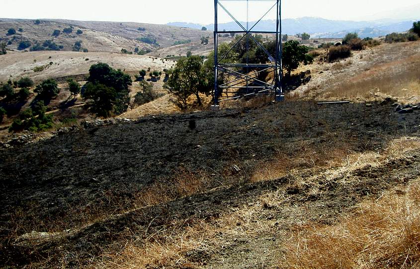
 This shows how close the fire came to the Mounted Ranger Unit at the Buck
Norred Ranch Site, which is in the center.
This shows how close the fire came to the Mounted Ranger Unit at the Buck
Norred Ranch Site, which is in the center.
 This is a view across the hill, looking toward the Muriel Wright Center
and Coyote Peak. Bernal Hill and the Mine Trail cut across the center.
This is a view across the hill, looking toward the Muriel Wright Center
and Coyote Peak. Bernal Hill and the Mine Trail cut across the center.
 This shows the upper limit of the fire, just to the foot of the power towers
on Bernal Hill.
This shows the upper limit of the fire, just to the foot of the power towers
on Bernal Hill.
 This is a view looking east. The fire stopped near the power tower in the
center. Bernal Hill and the Mine Trail are in the background.
This is a view looking east. The fire stopped near the power tower in the
center. Bernal Hill and the Mine Trail are in the background.
View from Heaton Moor and Curie:
 This is a view looking up from the corner where San Ignacio turns into
Heaton Moor. The hillside is blackened above the Coyote-Alamitos Canal,
which cuts through the center of the picture.
This is a view looking up from the corner where San Ignacio turns into
Heaton Moor. The hillside is blackened above the Coyote-Alamitos Canal,
which cuts through the center of the picture.
 This is a view from the Bear Tree Ranch. This shows the main part of the
fire. (When did that "No Parking" sign go up?)
This is a view from the Bear Tree Ranch. This shows the main part of the
fire. (When did that "No Parking" sign go up?)
View from the Coyote-Alamitos Canal East of Santa Teresa Spring
 This is a view from the canal levee just east of Santa Teresa Spring. This
is not a trail, but it is not posted until the gate up ahead, which is
usually locked, but not today.
This is a view from the canal levee just east of Santa Teresa Spring. This
is not a trail, but it is not posted until the gate up ahead, which is
usually locked, but not today.
 This may be ground zero. A tongue of burned grass runs down the canal,
then goes up the hill.
This may be ground zero. A tongue of burned grass runs down the canal,
then goes up the hill.
 Here is a view up the hill from above the canal, right at the westmost
limit of the fire.
Here is a view up the hill from above the canal, right at the westmost
limit of the fire.
 This is where the fire may have started. The burned grass runs up the small
landslide that has intruded into the canal and runs up the hill and down
the canal.
This is where the fire may have started. The burned grass runs up the small
landslide that has intruded into the canal and runs up the hill and down
the canal.
Controlled Burn at the Pueblo Area
This is not related to the fire of 10/8/05. This happened sometime in September. It was reportedly a controlled burn. It mostly took out the grass in the center of the Pueblo Area and singed the bottom leaves of some of the trees. None of the park structures were damaged. View of the Pueblo Area, looking across Bernal Road from the Mine Trail
towards Rocky Ridge and Coyote Peak.
View of the Pueblo Area, looking across Bernal Road from the Mine Trail
towards Rocky Ridge and Coyote Peak.
 This is a view from near the parking fee machine, looking towards the end
of the parking lot. The burned area stops before the picnic table. On the
far side, it runs up to the trail along the edge of the marsh.
This is a view from near the parking fee machine, looking towards the end
of the parking lot. The burned area stops before the picnic table. On the
far side, it runs up to the trail along the edge of the marsh.
 This is looking towards Coyote Peak from the parking lot by the parking
machine. The park road is on the left.
This is looking towards Coyote Peak from the parking lot by the parking
machine. The park road is on the left.
 These are the picnic tables near the parking lot by the Hidden Springs
Trailhead. The picnic tables and the area around them were untouched.
These are the picnic tables near the parking lot by the Hidden Springs
Trailhead. The picnic tables and the area around them were untouched.
 This is a view from the above position, looking towards the Group Picnic
Site, which was unaffected.
This is a view from the above position, looking towards the Group Picnic
Site, which was unaffected.
 This is from the parking lot at the end of the Pueblo Area near the Mine
Trailhead. The fire went up to the parking lot, but the picnic tables were
spared.
This is from the parking lot at the end of the Pueblo Area near the Mine
Trailhead. The fire went up to the parking lot, but the picnic tables were
spared.