Links:
POST Rancho San Vicente Hike, June 13, 2009
Peninsula Open Space Trust
POST on Facebook
POST: Rancho San Vicente
Flickr: Rancho San Vicente Pictures
Mercury News Article on Rancho San Vicente,
San Jose Business Journal article on Rancho San Vicente
Santa Clara County Parks
Almaden Quicksilver County Park
Calero County Park
Santa Teresa County Park
SCC Open Space Authority
Rancho Canada Del Oro Open Space Preserve
Canada Del Oro and Calero Trail Map
Mid-Peninsula Regional Open Space District
Sierra Azul Open Space Preserve
Bay Area Ridge Trail
Ridge Trail Guidebook
Park and Trail Pages:
Blair Ranch Hike 3/28/10
Blair Ranch Hike, 5/9/09
Doan Ranch Page 1, Page 2
Los Alamitos Creek Trail
Guadalupe River Park and Gardens:
Guadalupe River Trail
Guadalupe Creek Trail
Coyote Creek Trail
Bay Area Biking
Bay Trails, South Bay
Bay Area Parks
Friends of Santa Teresa Park
Almaden Quicksilver Park
Bay Area Back Pages
SF Bay Rec & Travel
Rancho Canada Del Oro Hike, 5/16/09
Rancho Canada Del Oro Hike, Mayfair Ranch Trail, 3/14/10
Calero Healthy Trails Hike, 4/25/09
Uvas Canyon Healthy Trails Hike, 2/21/09
Coyote Ridge Wildflowers, 4/13/08
Almaden Quicksilver Wildflowers and Views, Spring 2008, Part 2
Healthy Trails Walk, Almaden Quicksilver 3/28/09
Harvey Bear Ranch-Coyote Lake Pictures, 3/10/07, 3/21-21/09, 4/18/09
Palassou Ridge 6/6/09
Rancho San Vicente, 6/13/09
Mt. Madonna Geocaching Class, 7/11/09
Hellyer HDR Pictures 1/10/10
Almaden Quicksilver Wood Road Geocaching Class 1/16/10
Uvas Canyon HDR Pictures 1/23/10
Joseph D. Grant County Park, 1/31/10
Uvas Canyon Hike, 2/13/10
Santa Teresa Park Pictures:
Santa Teresa Park Mine, Fortini, Stile Ranch Wildflowers, 4/11/08
Coyote Peak, Rocky Ridge Wildflowers, Feb-Apr. '08
Bernal Hill wildflowers and views, Feb-Apr. '08 Part 1, Part 2
Coyote Peak, Rocky Ridge, Feb-April '08
Mother's Day Walk, Fortini-Stile, 5/4/08
Outdoor Photography Class/Wildflower Walk, Bernal Ranch/Hill 4/4/09
Geocaching Class, Fortini-Mine-Stile Ranch Trail, 4/11/09
Pre-Mother's Day Walk, Fortini-Mine-Stile Ranch Trail, 5/3/09
Healthy Trails Hike, Fortini, Mine, Stile Ranch Trails, 5/9/09
Santa Teresa Sunset Pictures 2/7/10
POST Rancho San Vicente Hike,
April 10, 2010
On
June 1, 2009, the Peninsula
Open Space Trust (POST) purchased
966-acre Rancho San Vicente. The ranch is located south of San Jose's
Almaden Valley between Almaden Quicksilver County Park and Calero
County Park. The ranch has been used for cattle
ranching since the 19th century. Cattle still graze on the land.
However, there were plans to develop the land. At one time, there was a
proposal to built up to 900 residences and an 18-hole golf course here.
The most recent plans included 300 units on the flat part of the land
and 16 large homes on 40-acre lots in the hills. Because of problems
securing permits and the real estate market, the landowners agreed to
sell the land to POST for $16 million, the same price they paid for it
in 1998.
POST acquired the property because they saw it was valuable for several reasons. It is a scenic area with panoramic views and spring wildflowers. Development would have impacted that. POST seeks to preserve agricultural land. The ranch has been used for grazing for over 50 years and will continue to be grazed. Over half the property, 506 acres, is covered by serpentine soils. Serpentine soils are relatively rare. They are poor in some nutrients, and have high amounts of others that are inhospitable to non-native vegetation, but support native plants and animals, some of which are endangered. However, automobile exhaust contains nitrogen compounds, which fertilize even the serpentine soil and promote the growth of non-native grasses. Grazing helps reduce the non-native grasses, allowing the native vegetation to thrive. The ranch is strategically located in the middle of large expanses of protected open space, including Calero County Park, Ranch Canada Del Oro Open Space Preserve, Almaden Quicksilver County Park, and Santa Teresa County Park. Keeping it undeveloped protects continuous habitats and migration routes for animals. Finally, it has the potential recreational benefit of providing trails linking the nearby parks.
The Santa Clara County Board of Supervisors authorized the County Parks dept. to proceed with the purchase on 8/11/09. One of the most important reasons for the purchase was the presence of rare and endangered species on the property. Protecting those species is the goal of the county's Habitat Conservation Plan. The ranch was purchased by Santa Clara County Parks for $16 million in 2009. The money came from the County Park's Charter Fund. It is now County Park property, but it is not yet open to the public on a daily basis. There will be guided tours of the park by the County Parks Dept. and by POST. Last year, POST held a guided hike on June 13, 2009. Since it was in the summer, the grasses were dry, and there were few wildflowers out. This year, on April 10, 2010, POST led a hike of the ranch in the springtime at the peak of the wildflower season. The hike began by the corral just off McKean Road, near Fortini Road. It followed established ranch service roads to the high point of the property. Here are some pictures from that hike.

This
is a picture of POST's satellite map showing the boundaries of Rancho
San Vicente. Click on the image for a full-sized version. You can see
how a large part of the east side of the ranch abuts Calero County
Park. The west side abuts New Almaden on Almaden Road and comes very
close to Almaden Quicksilver County Park.

Visitors entered the ranch off McKean Road, across from Rakstad Road, and a short distance from Fortini Road, which leads to Santa Teresa Park.

Visitors park by the corral. The hike begins beyond the corral.

Gordon Clark, conservation project manager for POST, led the hike.

One of the farm ponds provides water for the cattle and is a home for the endangered red-legged frog.

This is the Almaden-Calero Canal, which takes water from Almaden Reservoir to Calero Reservoir, totally by gravity. The canal bisects the ranch and is owned by the Santa Clara Valley Water District. The levee road along the canal is off-limits and will not be used as a trail.

The group crosses the canal and ascends the hill.

Creamcups and poppies grow on the hill above the canal.

There is a small tadpole-filled pond at the base of a hill.

White popcornflowers grow on the hill above the trail, which is covered with serpentine soil.

This part of the hill is covered with shooting stars, birdseye gilia, California poppies, tomcat clover, and creamcups. Because of the windy, cloudy weather, the poppies and creamcups were not fully open.

White popcornflowers and yellow seep-spring monkeyflowers grow down to the trail.

Close-up of seep-spring monkeyflowers, which grow at seeps and springs.

Behind the rock covered with red lichens are hills on the east side of the ranch. Cattle are grazing on the hill. 60 head of cattle graze on the ranch. In the background are the Santa Teresa Hills.
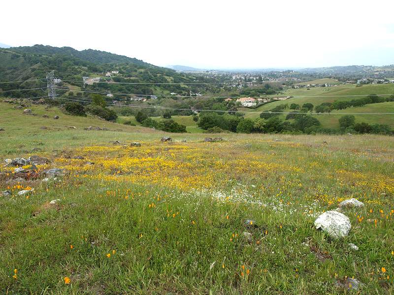
Poppies, popcornflowers, and yellow goldfields are on the hill over-looking the Almaden Valley and New Almaden. The hills of Almaden Quicksilver County Park are on the left.

Goldfields and poppies on the hill.

This
is a close-up of several flowers: an orange California poppy, yellow
goldfields, purple and white birdseye gilia, and light tan dwarf
plantain (bottom left corner and center right). There are also some
non-native grasses mixed in. The native dwarf plantain, plantago
erecta,
also called California plantain, is necessary for the survival of the bay checkerspot
butterfly, a federally-designated threatened species under the
Endangered Species Act. The butterfly lays its eggs on the plant. When
the larvae
hatch, they feed on the plantain. Adult butterflies drink nectar from
flowers, which include goldfields. The short goldfields and plantain
have a
hard time competing with the taller and early-sprouting non-native
grasses, so they need the serpentine grasslands, with the non-native
grasses held in check in order to thrive. Because of the loss of
habitat due to developement, the bay checkerspot, which was once common
throughout the bay area, is found in healthy numbers in one area:
Coyote Ridge, above the Kirby Canyon landfill. Bay checkerspots are
also found in Rancho San Vicente. Other protected animal species
found here include the California red-legged frog, California tiger
salamander, Western burrowing owl, and golden eagle.

The trail turns and begins a moderate ascent of the wildflower-covered hill.

Looking back, New Almaden is in the valley below the hills of Almaden Quicksilver on the right.

The Santa Teresa Hills are to the east. The high point on the left is Bernal Hill, which is partly in Santa Teresa County Park.

Looking back down the hill towards the South Almaden Valley. McKean Road is on the right. Much of the undeveloped land in the nearby hills below is part of Rancho San Vicente. It borders several of the private properties along Almaden Road and McKean Road.

The hill is covered with goldfields and California plantain.

The trail to the hilltop branches off to the left. There is a radio antenna on top of the hill. The trail follows the service road to the antenna.

The main ranch road continues level along the side of the hill, then runs along the tops of the hills to the right.

In the background are the bald peaks of Calero County Park on the left and Rancho Canada Del Oro on the right.

Looking north towards the Almaden Valley, wildflowers cover the rocky serpentine soil on the hilltop.

Approaching the transmitter station on the hilltop.

From the hilltop, we can see Calero Reservoir.
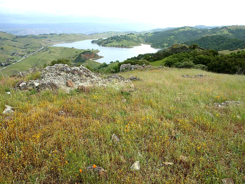
McKean Road and Calero Reservoir.

Gordon Clark talks about the geography of the ranch and the surrounding lands.

Geologist Dwight Harbaugh on the left talked about serpentine soils.


The view to the south from the peak shows the ranch road that runs along the hilltops. In the background are the hills of Calero County Park and Rancho Canada Del Oro.

Santa
Clara dudleya, a federally-registered endangered species, grow on rocks
in the park. The
succulents, a type of stonecrop, only grow in the southern Santa Clara
Valley. They are endangered because of the loss of habitat. Other plant
species of concern in the ranch include the most beautiful jewelflower,
smooth lessingia, and Mt. Hamlton thistle.

The group descends the hill. On the left, Cinnabar Hills Road zigzags up the hillside to large estates. Rancho San Vicente might have looked like that if development had been allowed to continue.


Looking back at the cattle grazing on the other hill.

Passing the small frog pond at the base of the hill.

Crossing the canal again.

Looking up the Almaden-Calero Canal coming from Almaden Reservoir.

Heading back to the corral at the end of the hike. It took about 1 3/4 hours and covered about 3.2 miles.
Google Earth Maps and Track
The
following tracks were obtained from a DeLorme PN-30 GPS unit,
downloaded into Topo 8, and imported into Google Earth to provide 3-D
satellite maps of the hike and associated lands. Click on each image
for a full-size version.

Looking southwest, the hiking route is shown above in blue, starting at the McKean road entrance at the lower right and the peak at the upper left. The thick white line that crosses the route is the Almaden-Calero Canal. In the background are New Almaden (right of center) and Almaden Quicksilver County Park (upper right).

This is the hiking route, looking southeast, with the crossing of the Almaden-Calero Canal on the lower left, and the peak in the center. The canal runs across the bottom of the page to Calero Reservoir in the upper left. In the background on the right is the Bald Peaks of Rancho Canada Del Oro.

This is a view looking northeast. The Rancho San Vicente peak is at the center right. Near the upper left, the blue line goes down McKean Road to Fortini Road and the Stile Ranch Trailhead of Santa Teresa Park, which is in the background. The high point of Santa Teresa Park is Coyote Peak, which is near the top center.

This is a view from Calero Dam in Calero County Park, looking southwest towards Rancho San Vicente, whose peak is on the upper right. The property line for the ranch is just above the Cherry Cove Trail in Calero.

This is a view looking northwest from the Bald Peaks at the boundary of Calero County Park (at the Chisnantuck Trail on the right) and Rancho Canada Del Oro Open Space Preserve (at the Catamount Trail on the left). Calero Reservoir is on the right. The peak of Rancho San Vicente is just right of top center.

This is a long view of Rancho San Vicente, looking south, with Calero on the center left, the Bald Peaks a little higher, left of center, the Blair Ranch near the upper center, New Almaden on the right edge, Almaden Reservoir above it, and Mt Loma Prieta in the background on the top right of center.

This is a long view of Rancho San Vicente, looking west from the peak, with New Almaden in the center, the Almaden Valley on the right, Almaden Reservoir left of center, Almaden Quicksilver County Park to the right of center, and the ridge of the Sierra Azul Open Space Preserve in the background, with Mt. Umunhum near the top center.
Topo 8 Maps

Above is a DeLorme Topo 8 map, with the hiking route show in red, downloaded from a PN-30 GPS receiver. It actually shows 2 hikes, the POST hike above and a County Parks docent hike on 2/28/10, which started at Calero Reservoir in the background and ended on the hillside ridge to the right.

This shows a closeup of the climb to the peak. The POST hike went up to the top of the peak. The docent's hike went along the side of the peak and along the top of the ridge to the right.
County Parks Hikes, 2010
This is a list of County Parks hikes in 2010 at Rancho San Vicente. See the County Parks Activities Calendar for the latest updates. Also see the Play Here Brochure.
- Saturday April 17, Outdoor Photography & Wildflower Hike, Rancho San Vicente, 9:30am-12:00pm. Join Docents Ron Horii and Cait Hutnik to learn the basics of outdoor photography while weaving through a colorful display of wildflowers. Meet at the Calero Reservoir parking lot to caravan. Bring sun protection, water and sturdy hiking shoes. This hike is in a “closed area” not yet open for public access. No restroom available except at meeting location. Pre-registration required, limit 20 people. (408) 355-2240.
- Saturday, June 5, Raptors Over the Rancho, Rancho San Vicente, 4:00pm – 6:00pm. Take a hike with a Park Ranger in this future County Park. Learn to identify our local sky-hunting hawks, eagles and other raptors. Participate in an activity that demonstrates hunting practices of these magnificent birds. Meet at Calero Reservoir, then caravan to the site nearby. Bring sturdy hiking shoes, sun protection and water. Note: This hike is in a “closed area” not yet open for public access. Restrooms not available except at meeting location. (408) 268-3883.
- Friday, June 18, Exploring Local Wildlife Hike, Rancho San Vicente, 5:30pm-8:00pm. Learn about local wildlife and tracking skills on this strenuous 2-mile hike in a beautiful future County Park. Meet at the Calero Reservoir parking lot to caravan to the tour location nearby. Bring sturdy hiking shoes, water, flashlight and binoculars (optional). Reservations required prior to 6/17. Note: This hike is in a “closed area” not yet open for public access. Restrooms not available except at meeting location. Pre-registration required. (408) 323-1107.
- Saturday, July 17, Ranger-led Hike, Rancho San Vicente, 9:00am-11:00am. Take a strenuous 2-mile hike with at Park Ranger to explore this neighbor to Calero and future County Park. Learn about the history of the rancho property and explore plants and wildlife living here. Meet at Calero Reservoir to caravan to tour site nearby. Bring sturdy hiking shoes, sun protection and water. Note: This hike is in a “closed area” not yet open for public access. Restrooms not available except at meeting location. (408) 268-3883.
- Friday, August 27, Tragedy of the Berryessas Hike, Rancho San Vicente, 6:00pm-8:00pm. Take a hike into the past in this future County Park. Learn of the tragedies that befell the Berryessa family and their rancho. Explore historic connections to the New Almaden Mines and take in spectacular views of New Almaden and Ranchos San Vicente and Los Capintancillos. Meet at the Calero Reservoir parking lot to caravan to the nearby tour location. Bring sturdy hiking shoes, water, flashlight and binoculars (optional). Reservations required prior to 8/23. Note: This hike is in a “closed area” not yet open for public access. Restrooms not available except at meeting location. Pre-registration required, space limited. (408) 323-1107.
- Saturday, September 11, Ranger-led Hike, Rancho San Vicente, 8:30am-10:30am
- Saturday,
October 9, Ranger-led Hike, Rancho San Vicente, 9:00am-11:00am
Neighboring Parklands, Open Space
Rancho San Vicente is a key piece in connecting islands of protected parklands and preserves into a continuous belt. The following parks and preserves are either contiguous or less than a mile from one to another:
- Chesbro
Reservoir County Park, 215 acres
for boating and fishing, no trails.
- Blair Ranch (SCCOSA), 865 acres, not yet open to the public.
- Rancho Canada Del Oro (SCCOSA),
3882 acres, 8 miles of trails.
- Calero County Park, 3500 acres,
17.6 miles of trails, boating lake
- Rancho San Vicente (Santa Clara County Parks), 966 acres, not yet open to the public.
- Santa Teresa County Park, 1688 acres, 18 miles of trails.
- Coyote Creek Trail (15 miles in Santa Clara County, partially complete in San Jose, Milpitas, Fremont)
- Anderson
Lake County Park, 3144 acres, 1250-acre Anderson Reservoir.
- Hellyer
County Park, 354 acres.
- Calero Creek Trail, Alamitos Creek Trail, Almaden Lake Park (City of San Jose)
- Guadalupe Creek
Trail,
Guadalupe River Trail (City of San Jose, partially complete)
- Almaden
Quicksilver County Park, 4152 acres, 34.2 miles of trails.
- Sierra Azul Open Space Preserve (MPROSD), 17,596 acres, 26 miles of trails.
- Lexington County Park, 914 acres, 475-acre recreation lake.
- Bear Creek
Redwoods OSP (MPROSD), 1345 acres, 10.3 miles of trails, access by
permit.
- St. Joseph's Hill Open Space Preserve (MPROSD), 270 acres, 4.2 miles of trails.
- Los Gatos Creek Trail (Santa Clara County, Los Gatos, Campbell, and San Jose, 1.5 miles unpaved, 8.2 miles paved, contiguous).
- Vasona
County Park, 150 acres.
- Los Gatos Creek County Park, 80 acres.
- San Francisco Bay Trail (500 miles when completed)
- Bay Area Ridge Trail (550+ miles
when completed)
Links on Rancho San Vicente
- Board of Supervisors Meeting Agenda 8/11/10
- Habitat Conservation Plan memo recommending the purchase of Rancho San Vicente
- Property map
- Morgan Hill Times: "Rancho San Vicente Protected"
- Sam Drake's pictures of the Rancho San Vicente Hike by County Park docents and staff, 2/28/10. Pictures and GPS Track.
- USFWS: Recovery Plan for Serpentine Soil Species of the San Francisco Bay Area.
- USFWS:
Designation of Critical Habitat for the Bay Checkerspot Butterfly
- Drive-by Extinction - Bay Checkerspot Butterfly
- Santa Clara Valley Habitat Conservation Plan
- Santa
Clara County Habitat Conservation Plan, Natural Communities
Conservation Plan Factsheet
- Santa
Clara County HCP/NCCP Conservation Planning Strategies Report